Showing posts with label River Stort. Show all posts

Monday, 19 August 2019

Strange text at Roydon Lock

On Friday we moved on from Burnt Mill Lock on the Stort to below Carthagena Lock on the Lee. Again, we were fortunate with the weather with the rain holding off until we'd tied up. Roydon Lock is welcoming ...

… and there is a piece of text on the sign which took me a little while to work out.

It reads: "Ore stabit fortis arare placeto restat".

Geddit?

Dobb's Weir Lock is another marked with red and green discs on the bottom gates.

But why?

Thursday, 15 August 2019

Meeting an almost boater and getting bashed by kayaks

We were up early today as we were being picked up later to have a meal with Lorraine and Mike in Hunsdon. I pulled the boat forward onto the water point and found it had good pressure. After a few minutes the tank was full and we set off from Bishop's Stortford back down the Stort.

At Sheering Mill Lock (I think it was) we met a man who delighted in telling us that he now had the funds to buy a boat. Richard, accompanied by Harvey, his dog, helped us through the lock by closing a gate or two. He said it was the first lock he had ever touched, but was obviously looking forward to doing many more. I think he said he was going to buy his boat in the midlands and then head for the Lancaster Canal. I hope it all goes well for you, Richard, and may you pick up plenty of useful tips from the blogs and vlogs you look at.

Feakes Lock is one of a number which have red and green discs painted on the bottom gates. Port and starboard? Anyone know what they are for?

The sun shone as we went through a wooded section - very pretty. I saw two kingfishers today, one flying past us going the other way which is most unusual. (No kingfishers in the photo as far as I am aware.)

We tied up just below Burnt Mill Lock, opposite the climbing wall and kayaking centre. There was a group of exuberant children having a training session on kayaks; the things kept hitting the side of the boat. In the end I moved the boat forward to be slightly further away. At precisely the same time their session finished and they all got out of the water.

I walked into Harlow to see what it was like. It was like this.

At least, that's the rather empty bit I saw. I used to drive through Harlow on my way to university before the M25 was built. I remember always looking out for boats on the river as I crossed it. (I also remember road signs with far too much information about small areas of the town.)

This evening we enjoyed the aforementioned meal with Mike and Lorraine; Lorraine is going to help me retrieve our car from Berkhamsted tomorrow which will be really useful.

Wednesday, 14 August 2019

What's so good about Waterway Routes?

First, a bit of explanation. What is "Waterway Routes"? Well, it's a map of the canals and rivers of England and Wales. It's available in two formats: a set of individual maps as (printable) pages on a computer file, suitable for laptop or tablet; or a scrollable and zoomable version for phone or tablet which can link with the device's GPS to track your position on the map.

So what's so good about it? Last year we tackled the Anglian rivers and Fenland waterways, a part of the connected network which doesn't make it into the Nicholson guides. We had obtained other guides, including an outdated Imray, but we found Waterway Routes invaluable for telling us where we were at all times, giving us up-to-date and accurate information of the location of facilities and moorings, and even showing which side of a river lock the lock landing and the control box were. Yes, it would have been possible to navigate to Bedford and back without WR but having the mapping system made it much easier.

How can it be up-to-date? Some users of the system report back to Paul Balmer, its creator, any updates required. These can be new or removed bridges or facilities, or other changes to the maps from the version they have. In fact, one of Paul's main selling points is that the maps are so up-to-date.

OK, so it's useful for rivers, especially where other guides are patchy or difficult to interpret. But what about on the canals? I mean, here we have Nicholson's and Pearson. Nicholson marks water points and other facilities, and I have used the maps for years with few difficulties. But where Waterway Routes scores is - again - its accuracy. Sometimes Nicholson is rather vague about the position of some facilities, but WR shows exactly where and which side of the waterway they are to be found. And there are the moorings. WR marks where there is a time restriction, and indicates the quality of the mooring by implying if there is anything to tie up to.

It's also very useful for route planning. Where Nicholson marks its maps with a pin every mile, Paul marks his every half-hour of cruising time. These half-hour points take into account locks and moveable bridges and are based on his actual times when doing the route himself. It is easy to calculate how long it would take to get from A to B; I have found the times remarkably reliable. We are currently at Bishop's Stortford; tomorrow we are aiming to get to Hunsdon Lock. The time marker at Bishop's Stortford is 7.5 hours (the time from the junction with the Lee Navigation); the time marker at Hunsdon Lock is 1.5 hours. So, barring the unexpected - and a lunch stop - it should take around six hours to get there.

I hadn't expected to find the location marker so useful. We use the system on a phone; its internal GPS indicates our current position by crosshairs in a circle. As we go along our historic route is tracked and appears as a thin red line on the map. Sometimes keeping track of exactly where you are using, say, Nicholson is not easy. What was the last bridge I passed? Is the Elsan point coming up or have I missed it? Whereas with WR there is never any doubt.

Any minus points? I think it's a mistake not to mark pubs, especially waterside ones. Paul's argument for not doing so is that they can close down or otherwise change so quickly that it would be difficult to keep on top of all the updates required. He says that, for example, aiming for a pub marked on WR in order to eat there only to find it had closed down would undermine the USP of the system, i.e. its accuracy. In my experience, though, most canalside pubs keep going year on year. Yes, a few have closed, but it's easy to check ahead with Google Maps or an internet search that a specific pub is still in business.

There is no editorial content; there are no paragraphs of information about the environs. Consequently I keep the Nicholson's guide open at the same time as WR for that extra bit of interest.

Here's an example of the route tracker. In Hertford a few days ago we went beyond the official end of navigation; the thin red line shows how far we got. (Apologies for the poor quality photo of the phone screen.)

The thick blue line, ending at the winding hole, is the navigation; our excursion to the south-west is clear. (And that was just the back of the boat!) The white circles, by the way, indicate access points from/to the bank.

Oh, another useful feature of Waterway Routes on a device with GPS is that it can tell you your speed. Has your speed dropped even though your revs are the same? You have something round the prop, you're pushing a raft of weed in front or the water has got very shallow. You can't do much about the last, but it could be worth checking the first two things.

Another thing the maps are good for is showing routes of former canals complete with locks. (Sarah of Chertsey has written eloquently on her exploration of the Chesterfield Canal with Waterways Routes.) Proposed canals such as the Bedford and Milton Keynes Waterway are also shown.

Declaration of interest: I was given a copy of Waterway Routes to review but I have tried to be objective. I have written this with no input from Paul, who will, no doubt, comment if necessary!

Tuesday, 13 August 2019

Another end of line reached: Bishop's Stortford

I managed to sleep despite the train horns, but we awoke early. Perhaps the hooting did disturb us. As a consequence we were under way at 0815. In the gaps between the trains alongside and planes overhead, having taken off from Stansted Airport, the river was very tranquil. Moored boats were getting scarcer and the river was getting twistier and more overhung with trees.


We didn't stop until we had reached Sawbridgeworth, which was our intended finish point for the day. We tied up above the lock on a good bit of piling. As it was lunchtime we walked back to the Riverside Café where I had a treat fry-up and Jan had a jacket potato with prawns. Then we walked into the village where we looked round the two charity shops and the church.

The name of this shop, offering an ironing service, made me smile.

The shop itself, as with many buildings in Sawbridgeworth, is clapboarded.

Back at the boat, knowing that rain was forecast all day tomorrow, we decided to crack on to Bishop's Stortford. There was still some uncertainty as to whether Twyford Lock would be open. The latest update on the CRT website said it was open, but notices at the previous lock said it was closed. We continued anyway.

There were no problems at Twyford Lock and we continued up the Stort to the end of navigation. I gently tried to see if we could nose under the bridge, but with the low water level we grounded with a few yards to go.

I couldn't get off to take a photo from the bank; here's the view looking back downstream.

We reversed to the winding hole and tied up at the end of the short line of moored boats, next to Allinson's flour mill. Fortunately this is nothing like as noisy as the flour mill in Wellingborough.

After tea on board we walked into the town for a brief exploration. We will do more in the rain tomorrow - walking, not boating - and have a "day off".

Monday, 12 August 2019

Low level on the Lee

We had a look round Hertford this morning - and wished that our schedule could have allowed for more time in this attractive town. As it is, we set off at about 1100 and stopped at Ware to have a quick look there too.

As the first visitor mooring - room for one narrowboat immediately beyond the trip boat - was occupied by kayaks we tied up to the bollards just before the Town Bridge. This gave me an opportunity to photograph the so-called gazebos, the curious riverside summerhouses at the ends of gardens.

I took the photo from the boat, but I couldn't actually see what was on the screen when I pressed the shutter. I had to hold the camera low so as to avoid foliage getting in the way. I'm quite pleased with the result - yes, I know, it's better than most of the ones I try to compose.
At Feildes Weir we turned left onto the River Stort Navigation. There is no sign at the junction, but the wide expanse of water is a bit of a clue. The turn is much more obvious when approaching from the south.

Between Ware and Stanstead Abbots one pound was rather low, causing some moored boats to list.

It must have been getting on for a foot lower than normal.

As we approached the first lock on the Stort the gates opened and an enormous-looking Dutch boat (a tjalk?) emerged.

What a splendid boat.

We tied up just above Hunsdon Lock - on piling! There's not much Armco-style piling on the Lee; perhaps there's a bit more on the Stort. We thought it was going to be a quiet spot, far enough from the railway line and the A414, but every train that passes gives four long blasts of its horn, each separated by a few seconds. Looking at the map I see that there are several places where footpaths cross the line on the level. The hooting must be for each of these. Hmm. I wonder when the trains will start running in the morning.

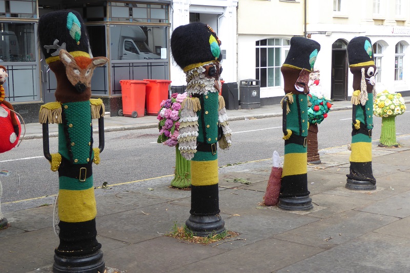
Oh, back to Hertford … one of the squares had been decorated - if that's the right term - by a mass of knitting. Yarn bombing, I understand it's called. Apparently it raises money for charity, but I find it difficult to see how.

All very clever, but what's the point of knitting covers for bollards when, presumably, jumpers, hats or tea cosies could have been created? You know, some products with a practical use. Or am I missing something?

Now to see if I can get some sleep between trains ...

Saturday, 2 March 2013

The Stort and the Lee from the train

Of more interest, probably, than the plane spotted from the train on Thursday were a couple of navigations.

First came the Stort (as I was going south). This is a hopelessly poor shot grabbed through the window. Somewhere near Sawbridgeworth, probably. You might be able to make out a cruiser through the trees. There's also the back end of a narrowboat if you look hard enough.


And then we crossed the Lee. We must have been going quite slowly - you can actually see some boats!


It made a nice change to be travelling in daylight.

Thursday, 3 February 2011

Timelapse: Bishop's Stortford to Dobb's Weir

The next instalment of our summer 2010 cruise timelapse film shows us travelling at high speed from Bishop's Stortford all the way down the Stort, and onto the Lee Navigation for a short distance down to Dobb's Weir. Here we tied up outside the Fish and Eels pub for beer and a meal. The food was good, but the pub had a noisy fan and there was a noisy gravel works opposite, so after we'd eaten we moved on downstream a couple of hundred yards for a quieter night.


Things to spot:

  • Stansted Express train passing over bridge as we approach (1.25)

  • stopping for David, Penny and Fergus at Sawbridgeworth (1.46), and then stopping for a fryup at the café (yes, we overshot, then winded, and had to reverse and wind again to resume our journey) (2.22)

  • boathook left jabbed into grass by side of lock (2.49) (I realised later that it had been left behind, and cycled back for it to find it had gone.  I suspected that the crew of another boat had taken it, so I carried on cycling.  I eventually caught up with the boat which had "rescued" the boathook, asked for it back, and cycled miles back to Willow with it.  Boats go very fast when you're chasing them!)

  • Rye House Junction (5.50)

Wednesday, 2 February 2011

Timelapse: Hertford to Bishop's Stortford

I've worked out that I don't need to "export" my timelapse films to get them onto YouTube. I can upload directly from iPhoto, where I load them from the timelapse camera's memory card. Doing it this way greatly increases the quality (but it does take a lot longer to upload). (For me, that is, it shouldn't affect your viewing, other than enhancing the experience (!))


Here's my latest offering, showing our 18th August 2010 cruise on Willow from Hertford on the River Lee Navigation to Bishop's Stortford on the Stort. Annoyingly, the camera's battery must have run out just before we got to the very end of the navigation, under the bridge which says "End of Navigation".

At Burnt Mill, opposite Harlow Station, we stopped for water and for me to have a shower at Moorhen Marina (3'19"); there are fine reflections at Sawbridgeworth (5'10"); and we suffer a downpour (6'24").

Now, do I go back and re-upload all my other timelapse films to the same quality?

Sunday, 23 January 2011

Long range duck feeding at Sawbridgeworth


As we came into Sawbridgeworth on the Stort Navigation last August there was a man standing on a first floor balcony chucking slices of bread at the ducks.


The pictures tell the story.

Wednesday, 29 December 2010

Caption competition


Is that you Bones?

Thank you, Debbie, for that caption.


No prizes, but if you write your caption as a comment I'll incorporate it into the post.

Offers so far (with a small amount of editing):

The locks can be a bit slow on this waterway (Halfie)

Will you ever bring me that tea? (Halfie)

Thats a rowing boat coming past. No its not, its a scull! (Captain Ahab)

Whose turn to steer? (H.S.)

Waiting for new licence from BW (Martin)

It'll take more than a skeleton crew to get this boat moving. (Jan)

Is that you Bones? (Debbie)

In 1960 they told me this was the Tardis & I'm still tryin' to get inside the darn thing ... (Heth)


Thank you all who have contributed. Debbie, your caption made me laugh out loud, so I've promoted it to top spot!

(edited to incorporate suggestions)

Wednesday, 3 November 2010

Cable tie saves fingers from paddle gear grease


When we did the Stort Navigation in the summer we came across a simple device I hadn't come across before. You know how sometimes you just can't help getting a bit of grease on your fingers when holding the pawl up while letting a paddle down? Well, someone on the Stort has come up with an ingenious modification: a cable tie attached to the pawl allowing it to be raised "remotely" while you keep clear of the grease. It's fixed so as not to interfere with the operation of the paddle gear.


And there was a lot of grease on the gear at Southmill Lock.

These mods were at many of the locks on the Stort.

Friday, 20 August 2010

Bishop's Stortford to Dobb's Weir

Back on schedule again, with boating if not blogging. I'm still a day behind. We left Bishop's Stortford at 0915 after I'd been to get a paper, some salad, cash, a disposable barbecue and some spare fuses. Spare fuses? Yes, the previous night I noticed that the inverter had died. I quickly established that that was because it was not getting its proper 12V. An inline fuse had blown. The reason for that wasn't too hard to find: a bodged joint in the supply line had been 'insulated' with insulation tape which had fallen off. The connection had shorted to earth. (Not my bodgery - not my boat!) I taped up the joint much more securely and replaced the fuse, and all is fine again.


Back to the cruising. We met David, Penny and Fergus at Sawbridgeworth, where we had an excellent fryup at the Riverside Cafe. David then had to do a certain amount of car shuffling so that Penny could return home to London later in the afternoon. Unfortunately the paths were not clearly defined, and when David found the navigation after parking the car he headed off in the wrong direction. We eventually met up at Roydon, where we enjoyed ice creams from the enterprising lock cottage.


At a later lock I thought I'd be helpful by fishing out some willow branches with the boat hook. I threw the pole over to Fergus on the other side of the lock so that he could help. It wasn't until we'd been going for at least half an hour that I remembered we'd left it behind. Immediately I pulled in to the bank, got my bike off, and cycled back upstream. If David had had navigation problems mine were just as bad, as what I thought was the towpath suddenly diverted off into the countryside. I pedalled for ages, past posh houses and through a park, taking a detour past the backs of gardens, before regaining the waterway. Now, of course, I didn't know if I'd missed the lock we'd left the boat hook at. So I cycled downstream again ... and fairly quickly came to the lock in question. No boat hook to be seen. The lock was full, though, so I guessed that the last boat through was heading upstream, and had probably 'rescued' the boat hook. It was unmissable, as Fergus had left it stuck upright in the ground. You have no idea how fast a narrowboat moves when you're chasing it on a bicycle! I'd gone a long way past Sawbridgeworth again - almost to Bishop's Stortford - when, at last, having decided that if I didn't come across it before the next lock I'd give up, I spotted a boat ahead, Popham Rose, travelling upstream. As I approached I saw on the cabin top our boat hook! I hailed the steerer, saying that we'd left our boat hook at a lock. He paused for an awkward moment, then reached forward and asked "Did it look like this?" He pulled closer to the bank and threw it over. I then started my second narrowboat chase of the day, trying to catch up Willow. This took MUCH longer than the original chase, because 1, I was more tired; 2, the wind was against me; and 3, I had further to go anyway.

Eventually boat, boat hook and I were reunited. And Jan made me a very welcome cup of tea, and David had gone off on HIS bike again to bring to car to Penny.

After this we had an uneventful cruise to Dobb's Weir, where we ate at the Fish and Eels pub. We had planned to stay there overnight, but the pub's fan was loud, and there was a sand and gravel works opposite still working at 8.30 pm, so we moved a couple of hundred yards further on and tied up for the night.


flypast in our honour(!) at Brick Lock on the Stort - what planes are these?

Note: Some of the pickup/set down places might be in slightly the wrong order. I wasn't very diligent with my log keeping. Sorry.

Thursday, 19 August 2010

Hertford to Bishop's Stortford

There's much I have to leave out of these posts: crayfishing at Hertford (not us) will have to wait. We left Hertford at 0750, arriving at Rye House Junction at 1040. Then we turned up the Stort. Trains and mills and planes seems to be the theme of this twisty waterway.

The Stansted Express must run every ten minutes or so, this one passing inches overhead on one of the many low bridges on this waterway.


Many of the mills are clapboarded (I think that's the right term for the white painted wooden boarding).


The planes had taken off from, or were about to land at, Stansted Airport.


Arriving at Bishop's Stortford we knew we could probably go no further when we came to this sign. I gently eased forward, and ground to a halt on the mud. This is where I took the photos from.