Showing posts with label Sheffield and Tinsley Canal. Show all posts

Monday, 25 August 2014

Chesterfield Canal (unrestored section), a snail convention and engine failure

Yesterday Andrew came to pick us up to take us to Renishaw, 10 miles south-east of Sheffield, for a walk along the towpath of an as-yet-unrestored portion of the Chesterfield Canal.

This was the first time I'd seen the Chesterfield Canal, and it was good to see that much of the towpath still exists and is waymarked as the Cuckoo Way. At Renishaw there is a short length in water under (a rebuilt) Bridge 18.

It looks a bit tight for a 70' boat.

I was pleased to discover an original-looking milestone hiding in the undergrowth: 7 miles to/from Chesterfield.

For much of the first part of the walk we were having to bash our way past nettles and brambles - long sticks we found were very useful. The canal itself was barely recognisable as a waterway, being colonised by trees and plants and shrinking to a ditch before disappearing altogether as here.

Where the canal crossed a tributary of the River Rother there would once have been an aqueduct. Now there's just a gap in the embankment.

After 2.5 miles we came across another part in water.

This is Staveley. Here there's much evidence of work by the Chesterfield Canal Trust and Waterway Recovery Group.

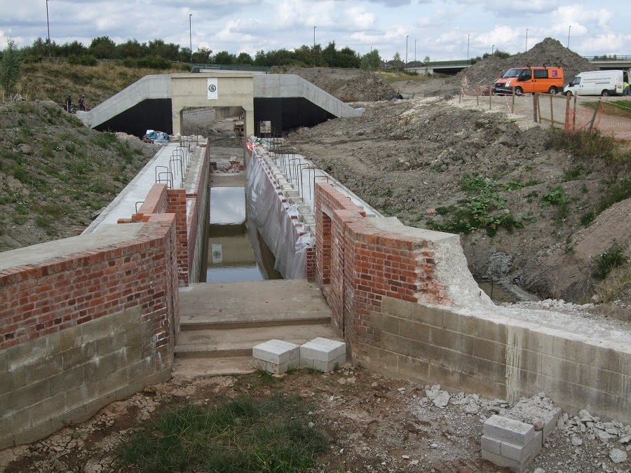
A new concrete lock has recently been lined in brick. I expect there's a good reason why the wall on the right has been partly nibbled away, can anyone enlighten me?

And here are some workers busy with (large) bricks and mortar. I feel I should be down there helping!

But it was time to finish our walk. The route back to the car was along a former railway line, now part of the Trans Pennine Trail, a route popular with cyclists.

And snails.

This is a vertical support wall of one of the new roads. The thin groove is crammed with snails.

But why?

I managed to grab a shot of Jan and Andrew walking along, with Caspar, his dog.


***********************

Now to bring this up-to-date.

We left Sheffield Basin at 0845 to set off for the top of the Tinsley flight. Our neighbour at the mooring, Ed, of Wandering Canuck, kindly wound the swing bridge for us. (We first encountered Ed at Barnby Dun a week ago; we have been bumping into him ever since.)

So we made our way out of Sheffield, past the crisp packets drying on the line ...

... and the skeletons discussing the finer points of life ...

... to the locks. Despite our having booked a passage days ago the CRT lockie didn't know we were coming. He was "penning" a widebeam down. It all worked out all right in the end, and we were at the bottom at noon.

One of the top gates at Lock 9 has an interesting sliding balance beam extension to give more leverage. Sadly this is now welded up and unusable.

At Rotherham Lock we met up with Chris Richardson of Richlow Guides again. We'd asked to buy the guide to the Trent, and she'd very kindly come to hand-deliver it, together with more very useful information on the tidal river. Chris is a fount of knowledge on the navigations of this region, and has a special interest in the Chesterfield Canal. She was telling us, with excitement, about the imminent launching of a replica working boat on the Chesterfield, one which originally would have had a mast and sail for working on the Trent. (I hope I have that right, Chris.)

Shortly after leaving the mooring below the lock, where we had stopped for lunch and a quick visit to Tesco, the engine suddenly lost power. It died completely after a couple of seconds, giving me no time to steer to the bank. Fortunately this was on a canalised part of the navigation, so we drifted to the side and were able to tie the centre line to a strong metal fence post. Now I had to see what the problem was.

My first thought was that we'd run out of diesel. Unlikely, as I'd dipped the tank while in Sheffield and there was plenty there. Dipping now showed that there was still plenty.

I'd have to check the engine. When I took up the deck boards I was surprised to see a lot of water in the engine bilge. It's a bit difficult to tell from the photo - the water in the engine bilge is centre left, reflecting the sky.

Perhaps the water here was coolant. I carefully removed the filler cap - but the coolant level was as it always is. Besides which, there had been no indication of overheating - no steam, no smell of antifreeze, no warning light and buzzer. While I was there I checked the engine and gearbox oil levels - both normal.

So where had all the water come from?

The answer: from the torrents of water pouring over the top gates while descending the Tinsley Locks. There had been one such "gusher" which Jan had said did go onto the deck boards a bit. But why would that have stopped the engine, especially as it was an hour or two after the event?

I unscrewed the diesel filter/agglomerator drain plug and let some liquid flow into a container. Ah - there was some water as well as diesel. Perhaps the mini-flood had cascaded through the gaps between the deck boards and got between the filter and the agglomerator bowl. There is some sort of rubber seal, but could water have penetrated? Thinking about it now, no, it couldn't. Otherwise there'd be diesel leaking out, which there isn't.

Anyway, after all these checks I turned the starter to see what would happen. After a little more cranking than usual the engine fired up (hooray!) and kept going (hooray again!). I left it on a fast idle for half-an-hour to see if anything untoward happened, which it didn't, and so then we carried on our way.

The engine behaved impeccably for the rest of today's cruise (we tied up at the moorings at Kilnhurst. Rather windy - the boat's being buffeted more than at any other mooring so far).

Further thoughts: The diesel filler cap would have taken the full force of the water pouring down. What if the seal around the cap isn't very good? I think water could well have got in. The more I think about it now, the more I'm sure that there must be a layer of water swilling around the bottom of the diesel tank. Some of this must have been sucked into the injectors, thus stopping the engine.

Methinks it would be a good idea to remove this water before going onto the Trent. A job for the morning (I have a plan). (It would be nice if it would stop raining.)

Saturday, 23 August 2014

Have we sprung a leak?

We were paid a visit this morning by Malcolm and Christine Richardson (the "Rich" part of "Richlow"), who came to see us in Sheffield Basin.

They gave us a copy of the Richlow Guide to the South Yorkshire Waterways as a thank-you for my letting them use my photo of Doncaster. I was amazed to find that the photo was already in the guide! Now that really is up-to-date. Beat that, Mr. Nicholson!

Here is the inner title page featuring my photo.

We had a good long chat about the (S)SYN and other topics. I'm impressed by Chris's knowledge of the local waterways, and impressed so far with what I've read in the guide. We'll see how easy or otherwise it is to use when under way. One thing I do like about the Nicholson's Guides is the little bits of OS maps which surround the blue line of the waterway. This forces north to be always up, a Good Thing. The Richlow Guide has rotated the segments of waterway to fit the portrait layout of the pages, meaning that "up" could be any direction. There is a very clear compass marking on each page, though. Another minor quibble might be that the scale varies from page to page, although each page states the distance covered, varying from one mile to four miles.

On the positive side there is a wealth of useful information accompanying each segment of waterway, with details Nicholson doesn't give such as locations of showers. I also like Richlow's use of letters rather than symbols for facilities such as Elsan disposal (ED) and rubbish disposal (RD). Nicholson's symbols for those two are easily confused.  Despite the lack of Ordnance Survey maps in the vicinity of the waterway, there seems to be enough information for the boater. The maps are certainly uncluttered. One excellent thing I've spotted is that locations of supermarkets are given, with the supermarkets' brands. Opposite each map page is a comprehensive-looking panel of navigational information, below which are descriptions of the general area and nuggets of history/explanations of why things are as they are.

I'm looking forward to using the guide as we cruise to Keadby next week, perhaps then I can write another review.

Back to today, and while running the engine for hot water and charging purposes I thought I'd redress yesterday's lapse and take the boat to the very head of navigation. This involved passing under the Straddle Warehouse ...

... winding by the Grain Warehouse ...

... and returning under the Straddle Warehouse again (different arch this time).

Ah. Now to the title of this post. When selecting an ale from the "cellar" under the well deck I happened to see that there was about two inches of water in there. Oops! Where did that come from? Fortunately all the paint tins/bottles/brushes etc. were on top of a layer of engineering bricks used as ballast, so I don't think there's much damage. I sponged out the rusty water into a washing-up bowl - there must have been a full bowl's worth of water down there. I took the photo after removing most of the water.  (And ale.)

The question is, as I have already asked, where did it all come from? I'm reasonably sure it's not canal water. It was dirty, but I think it was the rustiness which made it so. I suspect it's water from the tank, either leaking directly or from the many pipe connections. I wonder if it's anything to do with the filler neck popping up when I filled the tank recently. The tank is lined with a "hovercraft" liner (or so I was told); could water have got between the liner and the steelwork? Could it be this water which has found its way into the beer cellar?

After I'd sponged out the water I couldn't see any obvious spurting of water from the pipework, so all I can do is monitor the situation.

*******************

Andrew and Bekka have returned to Sheffield, and they came for tea on board. Here Andrew is demonstrating his prowess with mini-Jenga.

That's prowess in the tower-building department.

I'm glad they were in and came to see us. Now we have visited each of our two children by boat. Andrew proudly showed us his new car: a Volvo 850R with manual gearbox. Very rare, apparently, and very fast!

Friday, 22 August 2014

Sheffield steel

Rotherham to Sheffield

We've done it! We've got to Sheffield, another destination on our big summer cruise. From Northamptonshire we got here via parts or the whole of the following waterways: Grand Union, Stratford, Worcester and Birmingham, Birmingham, Staffs and Worcs, Trent and Mersey, Macclesfield, Peak Forest, Ashton, Rochdale, Calder and Hebble, Aire and Calder, New Junction, and South Yorkshire Navigation (including the Sheffield and Tinsley Canal). We set off from Thrupp Wharf Marina on 16th July, so it has taken us 37 days.

According to CanalPlan that's 299 miles and 330 locks. Our total distance will be slightly more as I didn't include our foray down the Saltisford Arm, nor the backtracking on the Peak Forest Canal to wind after watering up.

What better indication could there be of our proximity to Sheffield than piles of steel bars on the wharf?

To be clear, this is actually Rotherham, not Sheffield. And I somehow doubt the steel was made here. Is there any steelmaking left in Sheffield?

I liked the variety of colours and their reflections on this assortment of boats basking in the morning sun.

After a bit of a struggle at Ickles Lock, where opening the paddle on the same side as the boat - the usual practice - sent the bow shooting across to bang on the other side, we came to Holmes Lock. As we arrived, so did Dave, the CRT lockie.

Our ascent of the Tinsley Locks was smooth and painless.

At Lock 5 there is a plaque commemorating the efforts of the navigation company to keep the waterway open despite the lock being bombed in the war.

The British Waterways plaque reads:

1939 - 1945

On the night of December 15th 1940 this lock was severely damaged by enemy action during an air raid on the city.

This plaque is dedicated to the workforce of the Sheffield and South Yorkshire Navigation Company who strove to keep the waterway open under hazardous and extremely difficult conditions throughout the war.

This railway bridge sits heavily over the canal - but there was plenty of headroom. Lockie Derek took over from Dave for the upper part of the flight.

We shared the locks with Nekbor, being single-handed up to Sheffield.

And so, after those 300 miles and 330 locks we entered Sheffield Basin, aka Victoria Quays. I was so much looking forward to lunch that I neglected to go under the Straddle Warehouse to the very head of the navigation. I'll have to correct that before we leave.

This is where we tied up in front of the arches.

And another view, with a tram crossing on its elevated track.

There were coloured lights playing on the Straddle Warehouse after dark; this is a 1" exposure from the top of the boat.

We haven't seen the marina man - we have yet to "book in".

Thursday, 14 February 2008

Sheffield


Straddle warehouse, Sheffield Basin

No, we didn't reach here on our nine week cruise: this was yesterday on a visit to our son, Andrew. And Russell, here are the pictures I promised.


Straddle warehouse from the other side


Sheffield and Tinsley canal


Grain warehouse, Victoria Quays


Bridge 3, Sheffield and Tinsley Canal

And to show that we had a look round the city centre:


Sheffield Cathedral


Winter Garden


Outside the Winter Garden


Peace Gardens


And you can see the amazing weather we had for our trip. The day before - Tuesday 120208 - we walked from Hathersage to Hooks Car.


On the way to the top