Showing posts with label River Lee Navigation. Show all posts

Thursday, 29 August 2019

More Olympic Park waterways travelled

We had a long day yesterday - that's why I'm writing this the day after, rather than in the evening of the day itself (if you see what I mean). Long, but certainly interesting, and including waters new to us.

My alarm went off at 0600. I wanted to be sure that we were ready to go as soon as Tottenham Lock was mended. The first CRT team which looked at the problem said that if people were sent from Enfield then they could be here early, which they were. They pressed a couple of buttons and - look! - both top gates started to close. The problem had been a hydraulic pump overheating. No doubt they reset the system and all came back to life.

WB Pericles said that we could go first as we had the time constraint of a booked passage through Carpenter's Road Lock later that morning. At 0800 We were successfully worked through Tottenham Lock by CRT, then we made a dash for the Olympic Park. At Old Ford Lock we saw Joe, the helpful and friendly CRT person who was going to see us through Carpenter's Road Lock. In the end we must have been about 45 minutes later than our booked time of 0900 there.

This is the lock, approached under a highly reflective footbridge.

Carpenter's Road Lock is the only one in the country with a radial gate at each end. Having passed under the first gate ...

… the gate closed behind us; then the next gate was opened slightly to equalise the level with the river beyond. As this is all part of flood control, the level here could be higher or lower than the previous pound. In this case it was lower.

With the gate raised sufficiently we left the lock and turned right onto the Waterworks River. This is looking back towards the upper end of the Waterworks River, which I had wanted to explore but Joe said it was too shallow. It also seems to be outside CRT's jurisdiction, although Nicholson marks it as navigable.

Did I mention that we had been joined by David, Penny and Florence? No? They boarded at Carpenter's Road Lock. Do you like this twin peaks photo? That's the Olympic swimming pool.

Just before City Mill Lock we turned left onto Three Mill Wall River, passing a sculpture inspired, so the sign said, on pick-up-sticks.

We continued south for a short distance, then turned left to nose into the Prescott Channel. I had intended to go down to Three Mills Lock and wind above it, but the channel looked a bit too narrow with shallow sloping sides so I reversed out and went back to City Mill Lock.

This, again, is built to be able to cope with varying levels and has two sets of V-gates at each end.

Emerging from City Mill Lock took us on to the Bow Back River ...

… we wanted to make a very sharp right turn onto the City Mill River.

This manoeuvre completed, we came round past the Olympic Stadium, now the home of West Ham United FC (photos in a previous post) and rejoined the River Lee Navigation where we went straight up Old Ford Lock. At the junction with the Hertford Union Canal we turned left to go up (confusingly) Old Ford Locks. Our guests stayed with us until Regent's Park. Approaching Camden I got talking to two Spaniards who were interested in seeing us work through the lock.

We briefly considered seeing if we could find a space in Paddington Basin, but decided to carry on to Harrow Road Bridge 3 where we had moored three weeks ago. We tied up alongside Go with the Flow, another IWA festival attendee.

After another early start (Go with the Flow wanted to set off before 0730) we are now making our way through west London on the Paddington Branch.

Tuesday, 27 August 2019

Stuck at a broken Tottenham Lock


Sorry about the pause in posting - I have been rather busy at the festival. Now we are stuck waiting to go down a lock which won't play ball.

I'll try to come back to the IWA festival in my blog at a later date, perhaps when there isn't so much other stuff to write about. Meanwhile … we went down Waltham Town Lock at precisely 0915, the time we'd said we would. A short distance below the lock there is a new set of facilities so we watered up and attended to the Elsan. This took some time as our water tank was low after a week of no top-ups. At the next lock, Rammey Marsh, I found the previous boat through had left their BW key in the control panel (and with the hydraulic pumps running). While we were at the services the CRT boat Jena had passed us going in our direction; the key had a BW badge attached so I deduced that Jena had left it behind. I therefore phoned CRT to tell them. This was painful. First you have to endure the message suggesting using the website for renewing your licence, etc. etc. Then, eventually, you get to speak to a human being, but she is in north Wales and doesn't know anything about Jena or the Lee Navigation. She puts you through to London, but first there's a minute or two of muzak. At last, someone who might be able to help … except, hang on, I'm trying to help them! They say they will phone Jena and call me back. By this time we're through the lock and on our way to Enfield. I get a phone call from CRT, but it is the person who will operate Carpenter's Road Lock tomorrow morning checking that I'm going to be there. At Enfield Lock I get the promised call back from CRT about the key. Only they seem to have only the vaguest idea of what to do. Perhaps I could drop it in to the Enfield office. OK, where is it? Oh, I don't know. I could email you the address … No! Just tell me where it is in relation to the lock I'm trying to operate! At this point a CRT volunteer appears and picks up the key, but I didn't hear a "thank you". Maybe he said it, but quietly. He did, at least, stay to work us through the lock, just below which was the Enfield yard and Jena tied up! I could have saved myself a load of telephone stress and just lobbed the key at the boat as we went past. Oh well.

While we were descending the lock Jan went to the Tesco Express nearby for provisions. I didn't have to wait long before she reappeared with two large bags of shopping.

The next excitement, after stopping for lunch and then picking up my brother and his bike at Alfie's Lock, was to arrive at Tottenham Lock to be greeted by the crew of a widebeam opposite the official lock landing calling out to us that the lock was broken. We tied up alongside them; David and I went to see what the problem was. On the hydraulically powered lock one of the top gates wouldn't move from the fully open position, neither would the associated sluice do anything. CRT had been called an hour and a half previously, so all we could do was wait. I phoned CRT for an update of when someone might attend - they didn't know. They did know about the problem, though. By the time when, at last, a CRT van drove down the access road, there were six boats waiting to go down the lock and one waiting to come up. The time was now 5pm.

Another few minutes passed before two CRT employees walked up to the lock, carrying a long-handled shovel, a rope and a grappling hook. They proceeded to drag the shovel along the bottom by the recalcitrant gate but found nothing which would prevent the gate closing. When we pointed out that the sluice didn't work either the CRT people came to the conclusion we'd reached hours ago. Oh, it must be a hydraulic problem. They opened the box of tricks on the lock island and peered inside.

One of them, Joe, was on the phone to another CRT person talking about the problem for a while, then they pronounced that, because of the weather, the hydraulic fluid was too hot. It might work when it's cooled down a bit.

In the meantime, let's see if we can get you through the manual lock.

This lock clearly hasn't seen much action for a considerable time.

We got the bottom gates closed - I was helping with a windlass (CRT hadn't brought any windlasses) and filled the lock. This was successful - and the weed stayed on the surface of the water. The next operation failed, however. We could not open the gates. These are hydraulic like the gates on the parallel powered lock but operated by winding a windlass. So the team tried their dredging tactic again, but said that it felt like there was a load of bricks down there which were probably stopping the gates opening.

They left us to it, promising a hydraulic engineer in the morning. If he/she comes from Enfield then we could be on our way before too long. We were to feel free to try the gate when the hydraulics had cooled down. We did, and nothing happened. And now it is dark.

One good thing was that Joe was to be the person I was to see at Carpenter's Road Lock. It was he who phoned me this morning. He will know not to bother going if the lock isn't fixed in time.

The morning started with excitement too. A boat behind us on the festival moorings had broken down; I was asked if I could tow the boat - Wandering Whimbrel - to a space on the bank a few boat-lengths in front. I decided breasting up would be the easiest option, so that's what we did.

Now I must go to bed as I have to be up early to try the gate after a night of cooling down (we hope). Unfortunately it's going to be a warm and sticky night. We'll see what happens in the morning.

Saturday, 24 August 2019

The sun showed up but the people didn't

Day one of the bank holiday weekend and the IWA Festival of Water at Waltham Abbey is open to the public. It's a shame no-one told the public they could come. Numbers were disappointing, to say the least. Perhaps tomorrow will be better.

Still, here's a view from the footbridge looking towards Waltham Common Lock. Many boats were decorated with bunting.

I divided my time between the Boaters' Christian Fellowship stand …

… and the rope throwing stand. This is the IWA's Mike Moorse, festival director, showing how it's done.

It was a really hot and sunny day, perfect conditions to bring in the crowds you'd think. But where were they? The traders were not happy.

This was the view looking south from the footbridge. The unmistakeable bluetop, Kew, is below the flag left of centre.

Tomorrow is forecast to be even hotter than today, and we're out in the sun most of the time. We'll be up early to take part in a communion service in the entertainments marquee before the festival opens; then there's an open-air songs of praise service in the afternoon.

Tuesday, 20 August 2019

Arriving at Waltham Abbey

We're back on board after three days at home. There's a useful informal car park by Carthagena Lock, so that's where we left the car while we took the boat to the festival moorings between Waltham Common Lock and Waltham Town Lock.

On the way here we encountered a dozen small powered boats from Broxbourne.

Many in the boats were obviously Jews; at Aqueduct Lock a group of them helped with the gates. I talked to them about lock operation and let the children wind the paddle up - under close supervision. Jan asked if she could take the photo; permission was granted.

After tea we walked in to Waltham Abbey town centre and revisited King Harold's tomb. A lump of rock. (No photo - I didn't have my camera and it was almost dark anyway.)

Tomorrow I expect I'll be helping to put fencing up at the festival site.

Monday, 19 August 2019

Strange text at Roydon Lock

On Friday we moved on from Burnt Mill Lock on the Stort to below Carthagena Lock on the Lee. Again, we were fortunate with the weather with the rain holding off until we'd tied up. Roydon Lock is welcoming ...

… and there is a piece of text on the sign which took me a little while to work out.

It reads: "Ore stabit fortis arare placeto restat".

Geddit?

Dobb's Weir Lock is another marked with red and green discs on the bottom gates.

But why?

Wednesday, 14 August 2019

What's so good about Waterway Routes?

First, a bit of explanation. What is "Waterway Routes"? Well, it's a map of the canals and rivers of England and Wales. It's available in two formats: a set of individual maps as (printable) pages on a computer file, suitable for laptop or tablet; or a scrollable and zoomable version for phone or tablet which can link with the device's GPS to track your position on the map.

So what's so good about it? Last year we tackled the Anglian rivers and Fenland waterways, a part of the connected network which doesn't make it into the Nicholson guides. We had obtained other guides, including an outdated Imray, but we found Waterway Routes invaluable for telling us where we were at all times, giving us up-to-date and accurate information of the location of facilities and moorings, and even showing which side of a river lock the lock landing and the control box were. Yes, it would have been possible to navigate to Bedford and back without WR but having the mapping system made it much easier.

How can it be up-to-date? Some users of the system report back to Paul Balmer, its creator, any updates required. These can be new or removed bridges or facilities, or other changes to the maps from the version they have. In fact, one of Paul's main selling points is that the maps are so up-to-date.

OK, so it's useful for rivers, especially where other guides are patchy or difficult to interpret. But what about on the canals? I mean, here we have Nicholson's and Pearson. Nicholson marks water points and other facilities, and I have used the maps for years with few difficulties. But where Waterway Routes scores is - again - its accuracy. Sometimes Nicholson is rather vague about the position of some facilities, but WR shows exactly where and which side of the waterway they are to be found. And there are the moorings. WR marks where there is a time restriction, and indicates the quality of the mooring by implying if there is anything to tie up to.

It's also very useful for route planning. Where Nicholson marks its maps with a pin every mile, Paul marks his every half-hour of cruising time. These half-hour points take into account locks and moveable bridges and are based on his actual times when doing the route himself. It is easy to calculate how long it would take to get from A to B; I have found the times remarkably reliable. We are currently at Bishop's Stortford; tomorrow we are aiming to get to Hunsdon Lock. The time marker at Bishop's Stortford is 7.5 hours (the time from the junction with the Lee Navigation); the time marker at Hunsdon Lock is 1.5 hours. So, barring the unexpected - and a lunch stop - it should take around six hours to get there.

I hadn't expected to find the location marker so useful. We use the system on a phone; its internal GPS indicates our current position by crosshairs in a circle. As we go along our historic route is tracked and appears as a thin red line on the map. Sometimes keeping track of exactly where you are using, say, Nicholson is not easy. What was the last bridge I passed? Is the Elsan point coming up or have I missed it? Whereas with WR there is never any doubt.

Any minus points? I think it's a mistake not to mark pubs, especially waterside ones. Paul's argument for not doing so is that they can close down or otherwise change so quickly that it would be difficult to keep on top of all the updates required. He says that, for example, aiming for a pub marked on WR in order to eat there only to find it had closed down would undermine the USP of the system, i.e. its accuracy. In my experience, though, most canalside pubs keep going year on year. Yes, a few have closed, but it's easy to check ahead with Google Maps or an internet search that a specific pub is still in business.

There is no editorial content; there are no paragraphs of information about the environs. Consequently I keep the Nicholson's guide open at the same time as WR for that extra bit of interest.

Here's an example of the route tracker. In Hertford a few days ago we went beyond the official end of navigation; the thin red line shows how far we got. (Apologies for the poor quality photo of the phone screen.)

The thick blue line, ending at the winding hole, is the navigation; our excursion to the south-west is clear. (And that was just the back of the boat!) The white circles, by the way, indicate access points from/to the bank.

Oh, another useful feature of Waterway Routes on a device with GPS is that it can tell you your speed. Has your speed dropped even though your revs are the same? You have something round the prop, you're pushing a raft of weed in front or the water has got very shallow. You can't do much about the last, but it could be worth checking the first two things.

Another thing the maps are good for is showing routes of former canals complete with locks. (Sarah of Chertsey has written eloquently on her exploration of the Chesterfield Canal with Waterways Routes.) Proposed canals such as the Bedford and Milton Keynes Waterway are also shown.

Declaration of interest: I was given a copy of Waterway Routes to review but I have tried to be objective. I have written this with no input from Paul, who will, no doubt, comment if necessary!

Monday, 12 August 2019

Low level on the Lee

We had a look round Hertford this morning - and wished that our schedule could have allowed for more time in this attractive town. As it is, we set off at about 1100 and stopped at Ware to have a quick look there too.

As the first visitor mooring - room for one narrowboat immediately beyond the trip boat - was occupied by kayaks we tied up to the bollards just before the Town Bridge. This gave me an opportunity to photograph the so-called gazebos, the curious riverside summerhouses at the ends of gardens.

I took the photo from the boat, but I couldn't actually see what was on the screen when I pressed the shutter. I had to hold the camera low so as to avoid foliage getting in the way. I'm quite pleased with the result - yes, I know, it's better than most of the ones I try to compose.
At Feildes Weir we turned left onto the River Stort Navigation. There is no sign at the junction, but the wide expanse of water is a bit of a clue. The turn is much more obvious when approaching from the south.

Between Ware and Stanstead Abbots one pound was rather low, causing some moored boats to list.

It must have been getting on for a foot lower than normal.

As we approached the first lock on the Stort the gates opened and an enormous-looking Dutch boat (a tjalk?) emerged.

What a splendid boat.

We tied up just above Hunsdon Lock - on piling! There's not much Armco-style piling on the Lee; perhaps there's a bit more on the Stort. We thought it was going to be a quiet spot, far enough from the railway line and the A414, but every train that passes gives four long blasts of its horn, each separated by a few seconds. Looking at the map I see that there are several places where footpaths cross the line on the level. The hooting must be for each of these. Hmm. I wonder when the trains will start running in the morning.

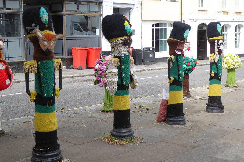
Oh, back to Hertford … one of the squares had been decorated - if that's the right term - by a mass of knitting. Yarn bombing, I understand it's called. Apparently it raises money for charity, but I find it difficult to see how.

All very clever, but what's the point of knitting covers for bollards when, presumably, jumpers, hats or tea cosies could have been created? You know, some products with a practical use. Or am I missing something?

Now to see if I can get some sleep between trains ...

Sunday, 11 August 2019

Going beyond the end of navigation

This morning we walked from the Fish and Eels pub mooring to Hoddesdon along a pleasant footpath. This crossed the railway and the New River. The latter comes as a bit of a surprise as it runs along the top of an embankment. No photo, sorry. In Hoddesdon we went to the parish church, St Catherine and St Paul.

We were back at the boat by 1300 and set off straight away. We kept on the Lee Navigation at Rye House, travelled through picturesque Ware and reached our destination, Hertford, at about 1745. I imagine many boaters would stop at this bridge.

Not us. We carried on past here ...

to the true end of navigation here.

We reversed back to the winding hole, still beyond the official end of navigation, and tied up outside the Old Barge pub on the last (first) legitimate mooring on the Lee.

Just as we were starting to reverse it started to rain quite heavily. By the time we'd tied up it had stopped, but I got pretty wet. (The previous two days rain came immediately after we'd stopped - we were a few minutes late today.)

We went to Dil's Indian Restaurant; Jan enjoyed her sizzling chicken nawab, but my madras was below par.

Saturday, 10 August 2019

Our boat damaged by rock thrown by boys

It's been very windy today, but we didn't have any problems. Not with the weather, anyway. This cormorant looked to be drying off in the breeze.

At Enfield there's a curious scene amidst the historic small arms factory buildings. A narrowboat in a rectangular pond.

The Harold Turpin is floating as evidenced by the wind moving it a little, but it seems to have very little ballast as it is sitting very high on the water. It bears the name of a former designer at the Royal Small Arms Factory - the "T" in Sten, as in the sub-machine gun.

As we approached Dobb's Weir Lock a group of about six boys was walking towards us on the towpath. One of them made a strange gesture with his fist. We called out a friendly "hello" greeting which they ignored. As we continued there was a sudden loud bang from the side of the boat. One of the oiks had thrown a sizeable missile at us. By the time I'd got the camera out they had disappeared. At the lock I examined the damage: three places where the paintwork had been punctured.

I shall have to touch this up straight away; unfortunately I'm still trying to locate the right grey paint, so it will have to be the wrong colour in the meantime.

As far as I can recall, this is the only time our boat has been damaged by vandals. Thinking about it now, if the rock had hit one of us on the head we could have been seriously hurt.

We tied up at the Fish and Eels pub just above the lock and ate there. Hertford tomorrow.

Edited to add: I have reported this incident to Essex Police (the towpath is in Essex; the other side of the river is Hertfordshire).

Friday, 9 August 2019

Low bridges bring Olympic rewards

Having spent weeks getting to London today we started to move away. First, as we were next to Spey
overnight, we watched Stephen start its Bolinder engine. One of the key operations was the heating of the "hot bulb" with a blowtorch. The flame is visible to the left.

When the bulb was hot enough it was time to spin the engine. This is done by foot, pressing down hard on a retractable pin on the flywheel.

After several attempts the engine fired and kept going. It was time for us to get going, so we reversed away and turned into the Limehouse Cut.

This was almost entirely covered with duckweed. Immediately past the Bow flyover (over which I have driven countless times) we turned right onto part of the network of waterways which surround the Olympic Park. We shall be passing through the two bookable locks after the IWA festival, but for now we were travelling on the Bow Back River and City Mills River which connect directly with the Lee Navigation. Here is City Mill Lock hiding under all the blocks of flats.

Round a bend or three and under a low bridge carrying the Northern Sewer Outfall …

… we came to the ArcelorMittal Orbit and the Olympic Stadium, now the home of West Ham United FC. Yes, we came under that low bit.

Whatever you think of the Orbit, it's certainly striking.

Carpenter's Road Lock is the other lock we shall use after the festival.

All too soon we were back on the "main line" of the Lee Navigation and ascending Old Ford Lock operated for us by a volunteer.

A short distance north of the lock I saw some powerful lights suspended from cherry pickers. The lights, mimicking sunlight, were shining through windows in the top floor of a run-down-looking office building. There must have been an expensive film production in progress.

Old Ford was the only lock with a volunteer lockkeeper but most of the others we passed through today were paired, one being manually operated and the other powered. I believe this is Tottenham Lock, the powered one. The manual lock is out of shot to the left.

At subsequent locks we made sure the boat was the same side as the control panel!

Other things to mention: the southern end of the Lee is one long - very long - line of moored boats. They go on for miles. I forgot to note where they began to spread out, but it wasn't very far from where we are now, which is at the Navigation Inn at Ponders End. The duckweed must have petered out somewhere too as there's none here. We passed Paul on Waterway Routes and exchanged greetings. (Which reminds me: I must write a post on how useful his mapping system is, verging on indispensable.)

The forecast rain held off apart from one very short shower. Until we'd tied up at the pub when, with excellent timing, it hammered down.

We had a drink in the pub but didn't eat there. It didn't seem the cleanest place. Where we sat there was a vermin bait trap on the carpet, covered in cobwebs. Oh, and there was no real ale. Tomorrow, wind permitting, we intend to stop at the Fish and Eel at Dobb's Weir.