Wednesday 31 August 2011

Over the canal under the railway under the motorway

10th April 2011

At Stewart Aqueduct over the New Main Line there is the extra thrill of passing under a railway line which is itself passing under the M5 motorway.


Well, almost. Strictly speaking, as the railway runs alongside the New Main Line, we must have passed under the tracks before crossing the aqueduct. But close enough.


Where's the motorway, I hear you asking?

It's this side.


An hour later we would be here again, only this time passing under the canal under the railway under the motorway...

Tuesday 30 August 2011

Titford Canal - another one for another day

10th April 2011

The half mile or so of the Old Main Line heading towards Spon Lane Junction is mostly under the M5, with its supporting pillars carefully positioned either side of the navigation.


On the right the Titford Canal heads up to the Titford Pools reservoir. In 2005 we got half way up the six Oldbury Locks before being told we couldn't go any further as there was a BW maintenance boat sunk at the top lock. We managed to wind - just - and went back down. This year we didn't have time to do justice to the canal, so it joins the list of canals still to be "done".


Titford Canal from Oldbury Junction

Monday 29 August 2011

Well, what else are spikes for?

10th April 2011

On the Old Main Line, just east of the Chemical Arm, is another angled wharf entrance, now bricked up. Accompanying the towpath bridge is a pipe also straddling the entrance. To deter people from taking the obvious challenge of walking along the pipe, arrays of spikes have been placed at each end.


The more upright of the spikes have been "decorated" with empty drinks containers, mostly beer cans. Well, they're just inviting it, aren't they? Of course, this involves a certain amount of shimmying up the pipe, so perhaps the spikes aren't the deterrent originally planned.


When I took this photo in April the far spikes hadn't been "finished". Have they been now?

Sunday 28 August 2011

Gower Branch

10th April 2011

Onto another new (to me) part of the BCN: the Gower Branch. This is a half-mile link between the new main line and the old main line via the three Brades Locks. The upper two of these are in a staircase, the only staircase on the BCN? Here were more exploding bulrushes.


Jan steered into the bottom Brades Lock with Ben and Ally on top.


The road bridge below the staircase is quite low: we had to remove the (useless) omnidirectional TV aerial.

Top Thirty, 2011 Week 34

Here is the UK Waterways Site Ranking as it stood at 0730 on Saturday 27th August 2011. This is taken, with permission, from Tony Blews's UK Waterways Ranking Site.


1 Canal World Discussion Forums (=)

2 Jim Shead's Waterways Information (=)

3 Pennine Waterways (=)

4 CanalPlanAC (=)

5 JustCanals.com - Forums (=)

6 CanalCuttings.co.uk (=)

7 Towpath Treks (+2)

8 Granny Buttons (=)

9 Water Explorer (-2)

10 ExOwnerships (+6)

11 Jannock Website (=)

12 Waterway Routes (-2)

13 boatshare (-1)

14 UKCanals Network (+4)

15 Narrowboat.co.uk (+4)

16 nb Epiphany (-1)

17 Canal Shop Company (-4)

18 nb Waiouru (-4)

19 Google Earth Canal Maps (-2)

20 Trafalgar Marine Services (=)

21 Captain Ahab's Watery Tales (=)

22 Chertsey (+1)

23 Narrowboat Caxton (+4)

24 Narrowboat Briar Rose (+5)

25 Derwent6 (-3)

26 nb Piston Broke (-2)

27 nb Lucky Duck (-2)

28 Narrowboat Bones (-2)

29 Halfie (+1)

30 Rock n Roll (-)


The figures in parentheses denote the number of places moved since the previous chart;
(-) denotes new entry or re-entry into the top thirty;
(=) denotes no change.


There are 143 entries altogether.

Saturday 27 August 2011

Apparition in canal

At first glance what do you see?


A dog swimming in the canal?


Or a coconut on its way to the Ganges? A coconut with a striking resemblance to a dog's head (but I couldn't tell you the breed).

Friday 26 August 2011

Birmingham New Main Line: a bridge with a tragic story; and forgotten wharves

10th April 2011

We turned right at Dudley Port Junction from the Netherton Tunnel Branch onto the Birmingham New Main Line, passing under another Toll End Works iron towpath bridge. Tied to the parapet were several floral tributes, presumably marking the location of a death.


This young lady stopped to read some of the messages.


All over the BCN are reminders of past industry, as here on the main line.


An inlet to a wharf or warehouse, perhaps, and at a curious angle. I suppose an entrance at right angles would have required a widening of the canal to allow boats to turn in, whereas a shallow angle such as this makes it easy for boats approaching or leaving in one direction. Boats needing to go the other way would have been able to wind at the next junction, in this case only a quarter of a mile away.

Thursday 25 August 2011

Netherton Tunnel, hydroelectric power and water shortages

10th April 2011

Wow! Two great tunnels in one day! Just an hour after leaving Gosty Hill Tunnel we turned right from the Dudley No. 2 Canal onto the Netherton Tunnel Branch, and straight into the tunnel itself.


Netherton Tunnel was the last tunnel of the canal age to be built, and opened in 1858. It has a totally different feel from Gosty Hill Tunnel: the latter is narrow and low with no towpath; the former is broad and high with a towpath on each side.


Emerging from the tunnel brings you into another world. You've left behind the winding Dudley Canals and are now in the no-nonsense, keep-the-boats-moving, straight-as-a-die New Main Line of the BCN.

Straight ahead is the Tividale Aqueduct which carries the Old Main Line of the Birmingham Canal.


Three girls watched us come out.


Under the aqueduct a turbine used to power a generator which ran the electric lighting in the tunnel.


What looks like drainpipes are, presumably, the water feed to the turbine. It seems extraordinary that, in this time of water shortages on some of our canals, one canal could have some of its water drained off merely to provide a bit of light in a tunnel.

And that has got me thinking: did canals suffer from water shortage in dry summers in the past?

Wednesday 24 August 2011

The tunnel with two names: Gorsty/Gosty Hill

10th April 2011


Just one more post on the tunnel on the Dudley No. 2 Canal (the navigable tunnel, that is - the other one, Lappal (or Lapal) Tunnel was abandoned following subsidence nearly a century ago). Yes, it's Gosty Hill Tunnel again.


Or should that be Gorsty Tunnel?


Looking at the top photo again: doesn't it just look inviting? I always feel privileged to be able to enter such tunnels. I'm allowed to steer myself through an ancient monument! Yes, I suppose I'm also allowed to drive along a Roman road many centuries older, but that doesn't give me the same sense of travelling back in time. Perhaps if the tarmac were removed, along with the road signs and all other modern paraphernalia - and I were driving a horse and cart along stone setts - yes, that might do it!

Tuesday 23 August 2011

Hawne Basin not so friendly

10th April 2011

As the sign in Gosty Hill Tunnel said, Hawne Basin was just a mile further along the Dudley No. 2 Canal. Here we are emerging from the tunnel into a former steelworks.


Hawne Basin itself is accessed under a towpath bridge, guarded by a statue of a lad with a length of string round a bollard.


There's also a sign indicating that this is the end of the navigation, but we wanted to go right to the end of the canal. After all, according to Nicholson's, the natives are friendly.


Unfortunately the natives weren't friendly at all, insisting that we wind at the basin entrance and not proceed the furlong or so to the end. Not wanting to upset anyone we did as requested. This is as far as we got.


We didn't even go into the basin.


Another little bit to do another day.

Monday 22 August 2011

A surprise in Gosty Hill Tunnel

10th April 2011

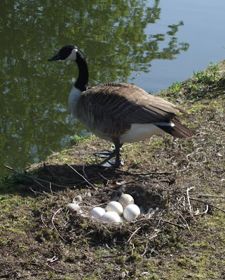
Onto the Dudley No. 2 Canal, then, and a Canada goose guarding eggs.


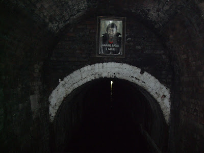
In a couple of miles Gosty Hill Tunnel appeared, with, apparently, plenty of headroom.


But what's this?


Aargh!


A scary Dracula with an incongruous distance notice: Hawne Basin 1 mile.

And, in case you hadn't noticed, a sudden diminishing in the amount of headroom. We had taken all the usual precautions, though, and lost nothing to the murky depths.


Something trying desperately to stay on top of the murk was this poor moorhen which found its peace shattered - and its very existence threatened - by twenty tons of steel coming through at two miles per hour.

Sunday 21 August 2011

Three superb iron bridges at Windmill End Junction

10th April 2011


After the Bumblehole Branch it was back to Windmill End Junction for the right turn onto the Dudley No. 2 Canal to head to Hawne Basin. The trio of iron black-and-white towpath bridges were looking very attractive.


Each bridge is labelled "Toll End Works".


This one, in at least three distinct places, shows the decades of wear from gritty tow ropes.

Top Thirty, 2011 Week 33

Here is the UK Waterways Site Ranking as it stood at 1215 on Sunday 21st August 2011. This is taken, with permission, from Tony Blews's UK Waterways Ranking Site.


1 Canal World Discussion Forums (=)

2 Jim Shead's Waterways Information (=)

3 Pennine Waterways (=)

4 CanalPlanAC (=)

5 JustCanals.com - Forums (=)

6 CanalCuttings.co.uk (=)

7 Water Explorer (=)

8 Granny Buttons (=)

9 Towpath Treks (=)

10 Waterway Routes (+2)

11 Jannock Website (=)

12 boatshare (-2)

13 Canal Shop Company (+2)

14 nb Waiouru (-1)

15 nb Epiphany (+1)

16 ExOwnerships (+1)

17 Google Earth Canal Maps (+3)

18 UKCanals Network (-4)

19 Narrowboat.co.uk (-1)

20 Trafalgar Marine Services (+1)

21 Captain Ahab's Watery Tales (+4)

22 Derwent6 (+5)

23 Chertsey (+7)

24 nb Piston Broke (+2)

25 nb Lucky Duck (-2)

26 Narrowboat Bones (-2)

27 Narrowboat Caxton (-5)

28 Takey Tezey (-9)

29 Narrowboat Briar Rose (=)

30 Halfie (-2)


The figures in parentheses denote the number of places moved since the previous chart;
(-) denotes new entry or re-entry into the top thirty;
(=) denotes no change.


There are 145 entries altogether.

Saturday 20 August 2011

Bumblehole Branch

Yesterday I talked about the Boshboil Branch. About a furlong back down the Dudley No. 1 Canal is the Bumblehole Branch, to which I went next. It's accessed under a very low Dunn's Bridge, so low that I had to whip the tiller pin out at the last moment to avoid it getting bent. Here was a flexible boom across the cut, similar to that at the entrance to Walsall Basin. This time I knew what to do, and allowed the boat to push it out of the way.


There were lots of moored boats in this branch, on what I assume are residential moorings. Nobody seemed to mind us creeping carefully past them.


The branch terminates in a "Y": the above photo shows the extent of our passage along the right fork. Then we reversed to the end of the other stub.


I wouldn't be at all surprised if the other side of the caravan and white van is a perfectly ordinary suburban street, with no indication that there's another (watery) world just feet away.


What a lovely outside lavatory! What a view you'd have from your throne! The octagonal building is reminiscent of a toll house - it couldn't be, could it?


Enter "Bumblehole" into streetmap.co.uk and you will be taken to the Staffs and Worcs Canal and Bumblehole Meadows right by Bumblehole Lock and Bumblehole Bridge (although the latter two are not identified on the mapping website). There's no mention of this Bumblehole.


Friday 19 August 2011

Boshboil Branch

10th April 2011


On the Nicholson's Guide the wonderfully named Boshboil Branch and the Bumblehole Branch look as though, at one time, they might have joined up to form a loop just south of Netherton Tunnel. Now the Bumble Hole Pool (former mine workings?) gets in the way. As I've mentioned before, small branches are there to be explored, so, before anyone else was up, I gently cruised to the end of the Boshboil Branch, just a few yards from where we were tied up the previous night. And to prove it, here are a couple of photos from the end.


The above photo was taken from the same place as the top photo, looking back towards Windmill End Junction. Tomorrow I'll post about the Bumblehole Branch.

Thursday 18 August 2011

The sign (what's left of it) at Bumble Hole Pool says it all

10th April 2011

This is Bumble Hole Pool at Windmill End near the junction of Dudley Nos. 1 and 2 Canals at half-past-seven on a spring morning.


And this is the interpretive sign on its bank. "Bumble Hole Pool Wildlife" appear to have been at work on the sign.


Even Andrew Denny's graffiti removal cloths would struggle with this vandalism.